
|
Cartography tools for Fantasy Maps |
... with Inkscape
Mapping your Fantasy Cartography in Inkscape...
What you need
- Inkscape (you can download it here)
- Any hi-res image with a scale (you can download the image I used in this tutorial)
NB: this tutorial is made with Inkscape 0.92
Importing
Start Inkscape and drag & drop your image into it. Choose to embed it.

You'd better to lock the image. Right-click on it, then "Object Properties" and "Lock".

Scaling
Determine a known distance on you map. For instance, I know that the scale bar in my image is 480 miles (see figure A).

Use the  "Bezier" tool to draw a straight line, equal in length to your known distance. I've
created the blue line you see in figure B.
"Bezier" tool to draw a straight line, equal in length to your known distance. I've
created the blue line you see in figure B.

Now go to "Extensions" menu > "Visualize Path" > "Measure Path...".
- Remember to select the line.
- Keep "Length" as measurement type.
- Notice the "Scale Factor" set to 1,0. For now, let it so.
- Notice also that, in the "Length Unit" combo-box, "miles" is not an option. Just choose another one (better if small) and pretend it's miles. I'll go for "cm" (centimeters).
- Click on "Apply".

A label will appear above the line, expressing its length in centimeters.

Now forget about the measurement unit, or "cm". Just pretend that "cm" is "miles".
With the scale factor set to 1.0, Inkscape is telling us that the line is 15.93 long, while it should be 480.
The scale is simply 480 / 15.93 ≂ 30.1 → put this value as scale factor and try again.

It now shows that the line is 479.48 "cm" long. If you just pretend that "cm" is "miles", it's pretty accurate.

Done!
From now on, you can measure any line, curve, path, etc. drawn on this map. Just remember to set the scale to 30.1 and to consider centimeters as they would be miles.
Let's see a couple of examples...
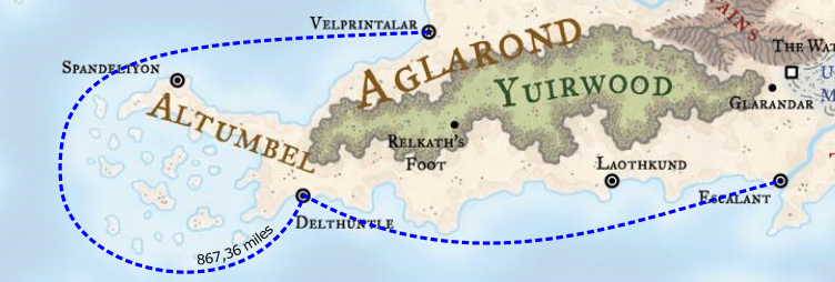
How long is for a ship going from Velprintalar to Escalant, via the port of Delthuntle, avoiding all the sea rocks off the Altumbel shore?

Since the distance is a simply label, you can  edit it and change "cm" to "miles" freely.
You can use the  "free hand" tool to draw the route of a group of fugitive randomly fleeing through
the Endless Wastes. Tip: simplify the line with CTRL + L before measuring it.
"free hand" tool to draw the route of a group of fugitive randomly fleeing through
the Endless Wastes. Tip: simplify the line with CTRL + L before measuring it.
